42 for Loowit’s 42nd vol. 5: Cataclysm
It’s a beautiful, quiet morning with spectacular weather, and then suddenly it isn’t. An earthquake strikes, the bulge gives way, and the volcano blows up and out.

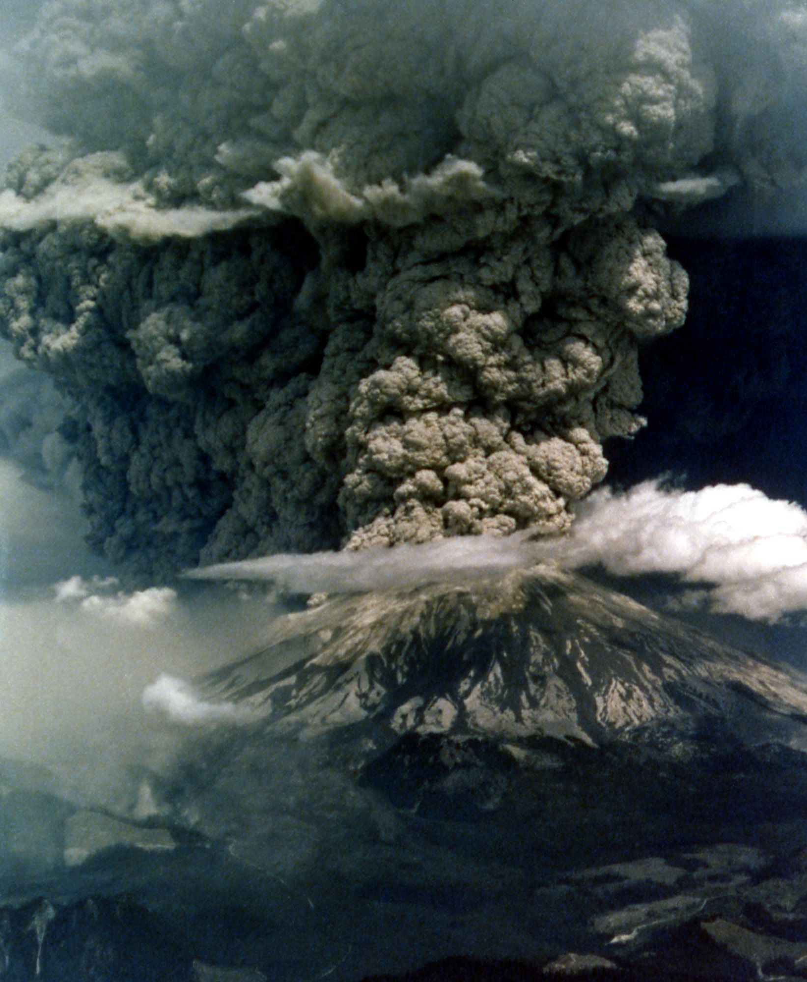
Mount St. Helens in eruption. Aerial view of base of eruptive column, crater rim at right. Shows “cauliflower” effect in column. 1235 hrs PDT. Skamania County, Washington. May 18, 1980. Caption and image credit: USGS
This actually isn’t a particularly large eruption. Between the lateral blast, Plinian ash column, and the pyroclastic flows, it totals only about 1.4 cubic kilometers of material. Barely a VEI of 5. But if you’re in it, it seems large enough to have swallowed the world. It is, indeed, cataclysmic.

The eruption column dominates the landscape. You can see it creating its own weather. Credit: USFS
Imagine watching from Portland, OR as over 1,000 feet of the summit vanish.

Mount St. Helens Erupts, Portland View, May 18, 1980. Gifford Pinchot National Forest Historic Photo. Caption and image credit: USFS
The blast is so fierce that it propels singed branches and pinecones all the way to Klickitat (Mount Adams), 34 miles away.

Mount St. Helens in eruption on May 18, 1980 showing portion of crater and Mount Adams in background. Skamania County Washington. Caption and image credit: USGS
The winds generally blow east, so eastern Washington end up under massive ash clouds. The roiling, boiling, gray mass blots out the sun, and leaves towns buried under inches of fine, sharp gray rock.

The advancing ash cloud from Mount St. Helens as seen from the ground in eastern Washington. May 18. Caption and image credit: USGS
Meanwhile, back at the volcano, phreatic explosions, caused by chunks of juvenile lava flash-heating the ice from dismembered glaciers and water from debris-choked lakes, turn the formerly verdant lands into a cratered moonscape.

Oblique aerial view of secondary steam fumarole near Spirit Lake. Fumarole is 300 feet in diameter. Eruptions occurred hourly and continued for two months after May 18, 1980. Skamania County, Washington. 1980. Caption and image credit: USGS
The most destructive eruption in living memory in the lower 48 leaves 57 people dead and entire regions devastated. No one who lives through that day will ever forget. It seems every living thing has been stripped from the slopes, never to return.
But we’ll soon see that volcanoes are as much agents of creation as destruction, and life is surprisingly tenacious in the face of a cataclysm.
Featured image: Great eruption of Mt St Helens, 2 PM, May 18, 1980. Caption and image credit: NPS /
Oman/Combs

Rosetta Stones and Dana Hunter’s Unconformity wouldn’t be possible without you! If you like my content, there are many ways to show your support.


![]()
This website is a member of the Amazon Affiliates program. I get a small commission when you use my affiliate link to make a purchase.

Thank you so much for your support!