Tag: history
Eldfell Eruption: 50 Years Ago, a Village Fought the Lava and Won
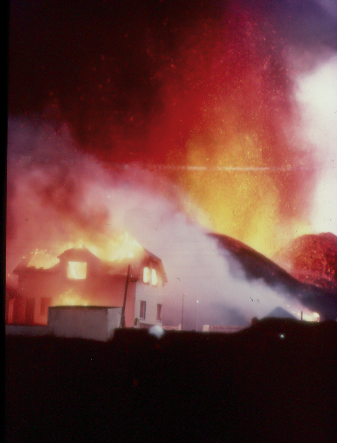
Imagine going to sleep one night, and then being awakened in the small hours of the morning by a volcano that’s suddenly erupting right beside your town. Fifty years ago, this was the scene for residents of the small Icelandic fishing town of Heimaey, on the island of the same name.
One day, I will write it up properly. It’s an eruption that has fascinated me since childhood, and it’s a wonderful example of people battling lava and pretty much winning. But today is not that day. Instead, I have a collage of videos for you, including one featuring a younger David Attenborough on location. How awesome is this? (more…)
The Perfect Book for Coal Lovers (and Also Haters)
It’s Coalmas! Around this time of the year, some people threaten to leave coal in our stockings like it’s a bad thing. Pfft. Geologists know coal is actually a very amazing rock and very cool to have a lump of.
If you’re not convinced that holding a several hundred year-old shiny black flammable vestige of a really unique geological era is a fabulous thing, or if you just want to marvel at its remarkable past, let me suggest Coal: A Human History by Barbara Freese. This is one of the best books I read in 2022. And I’m not just saying that because I’m a coal miner’s daughter with a soft spot for rocks that burn. I would have loved it even if I hated the vile, polluting stuff.
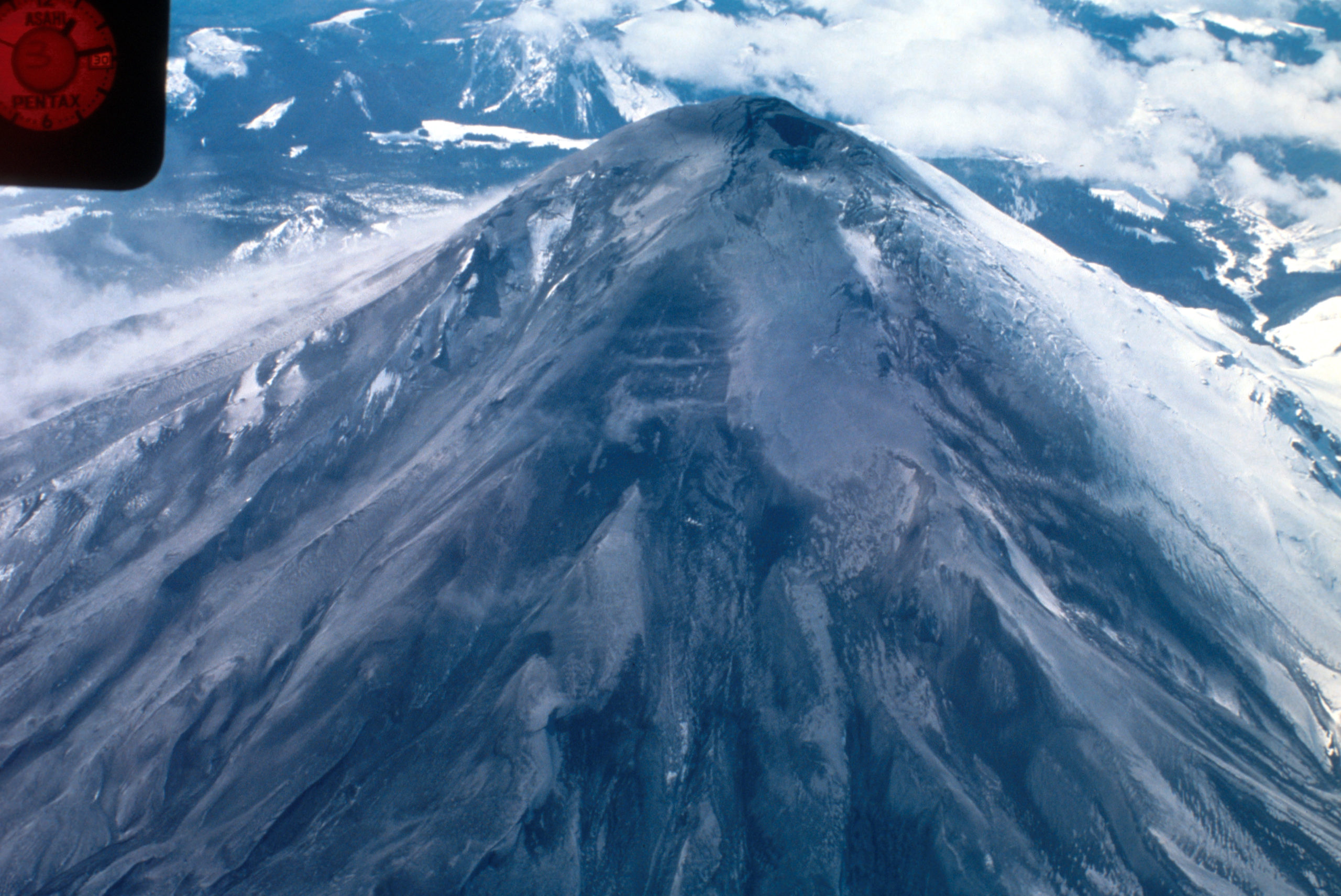
42 for Loowit’s 42nd vol. 7: Reprise
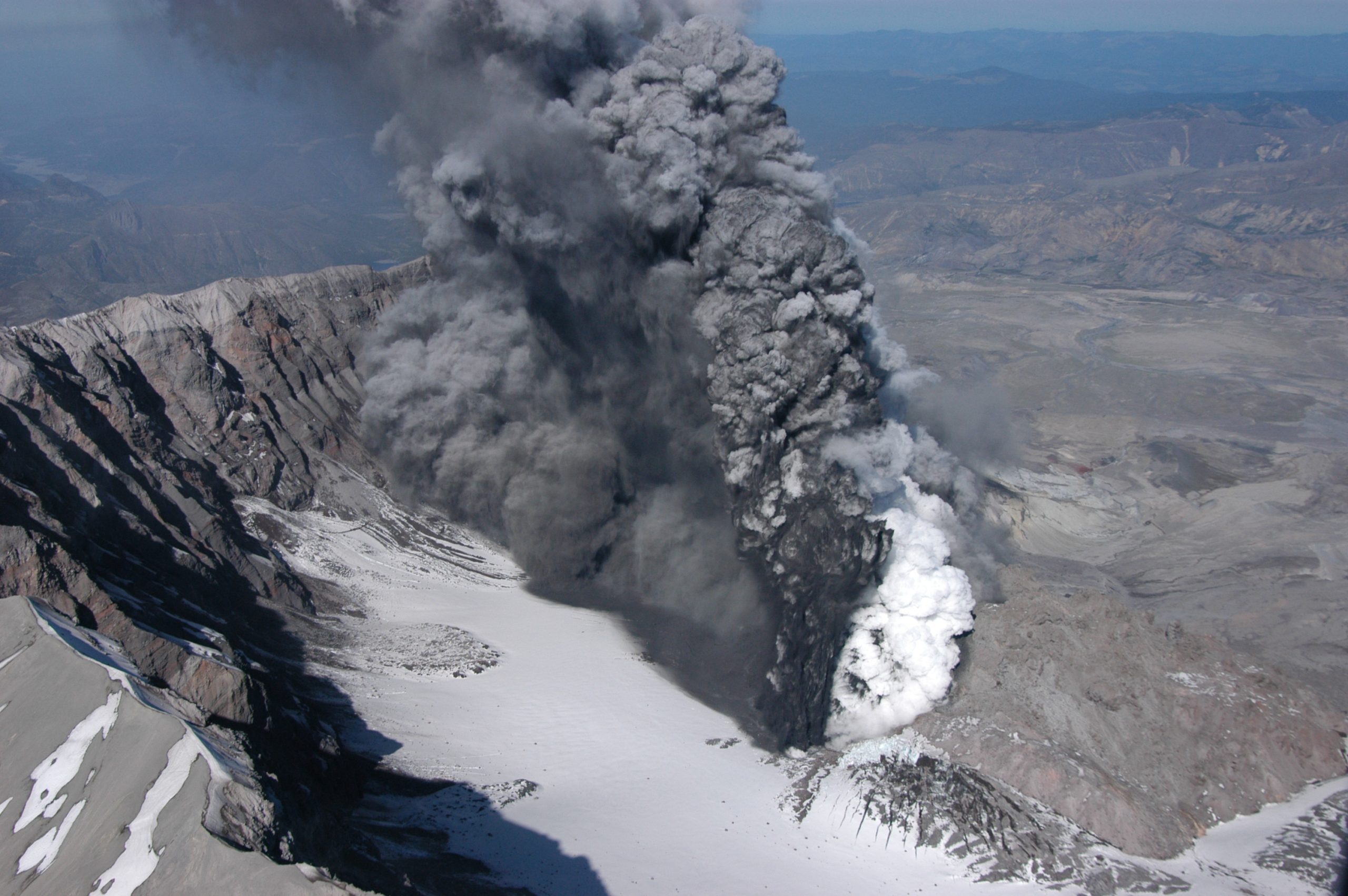
There was life in the old girl yet.
To be fair, though, Loowit (Mount St. Helens) isn’t very old as far as volcanoes go. So when she rumbled awake in late September of 2004, volcanologists weren’t terribly surprised. She’d slumbered for less than 20 years after her 80s eruptive sequence, but it wasn’t shocking to see magma on the move again.
Her prompt eruption on October 1st signalled a new phase of dome building. And this time, we had better cameras, better monitoring equipment, and the plans in place to do some serious monitoring.

Dome within Mount St. Helens’ crater is hot and glowing as it grows, viewed from Johnston Ridge Observatory (JRO), with base of small steam and ash plume. 11/4/2004. Caption and image credit: USGS
She put on a beautiful show. (more…)
42 for Loowit’s 42nd vol. 6: Beauty in Destruction
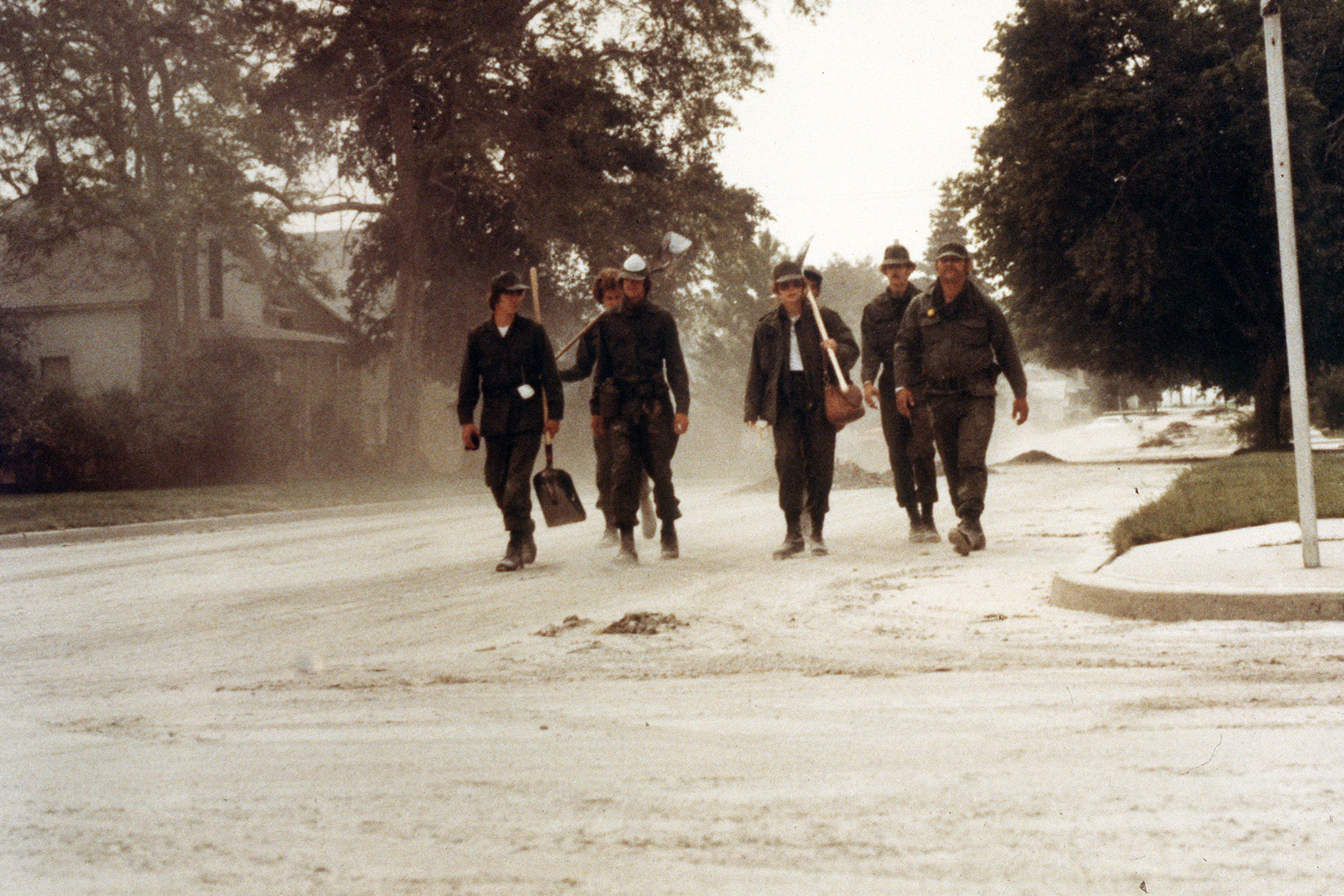
Volcanoes leave one heck of a mess to clean up when they explode near civilization. It’s not pretty, although as you can see above, it sometimes looks pretty metal.
While Washington State called out the National Guard and folks figured out how to cope with the copious ash, volcanologists picked through the ruins of a once-verdant forest, measuring various volcanic deposits and learning all they could from them. At first, it was shocking. But once you started adjusting to the change, you could start seeing the beauty in the devastation.
Look at the channel carved through the debris avalanche here: you can see gorgeous reds in the gray where hydrothermally altered rock from the former summit mixed with the more prosaic grays of younger material. The iron-stained creek flowing through added more color to the moonscape. It was alien and strangely pretty. (more…)
42 for Loowit’s 42nd vol. 5: Cataclysm
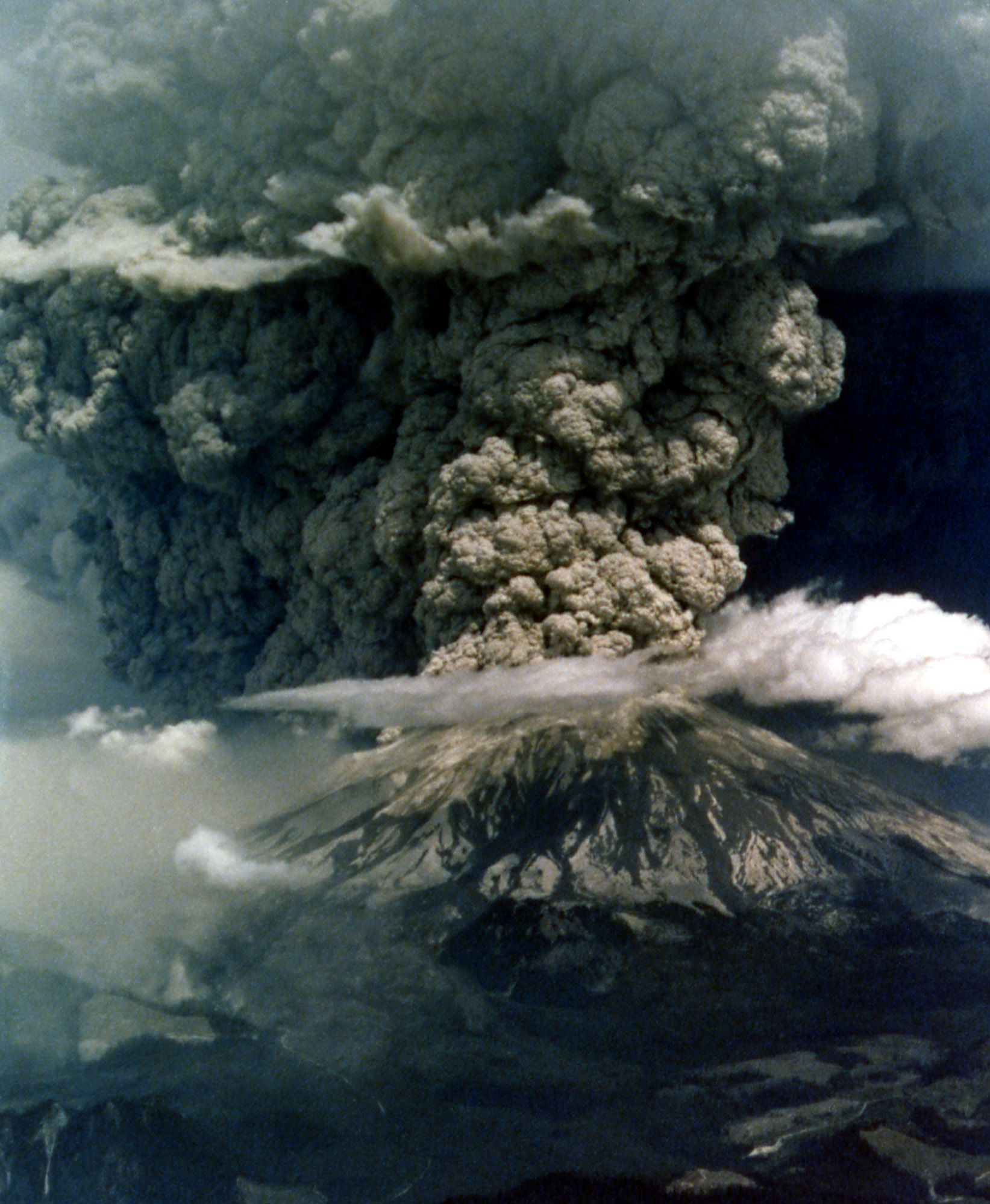
It’s a beautiful, quiet morning with spectacular weather, and then suddenly it isn’t. An earthquake strikes, the bulge gives way, and the volcano blows up and out.

Mount St. Helens in eruption. Aerial view of base of eruptive column, crater rim at right. Shows “cauliflower” effect in column. 1235 hrs PDT. Skamania County, Washington. May 18, 1980. Caption and image credit: USGS
This actually isn’t a particularly large eruption. Between the lateral blast, Plinian ash column, and the pyroclastic flows, it totals only about 1.4 cubic kilometers of material. Barely a VEI of 5. But if you’re in it, it seems large enough to have swallowed the world. It is, indeed, cataclysmic.
42 for Loowit’s 42nd vol. 4: Menacing May
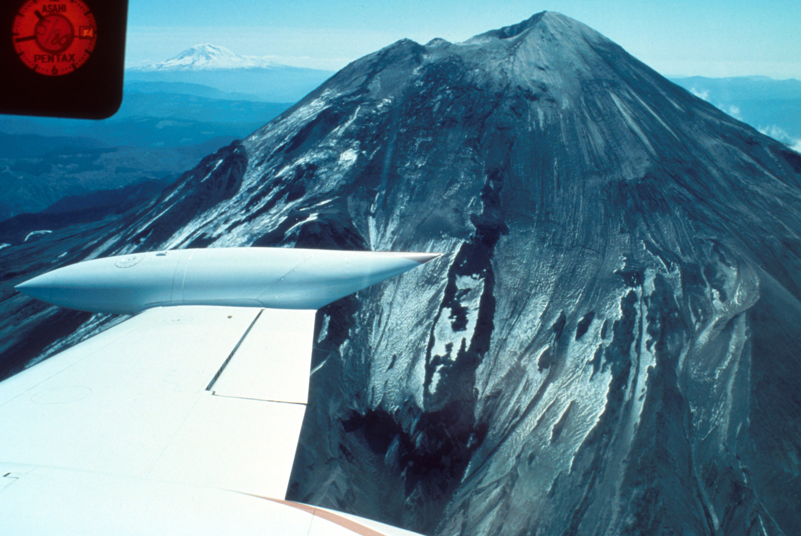
May had begun with an ominous quiet.
Ominous? Surely a restless volcano quieting down is a good thing!
Yeah, not when you’ve got one flank of the mountain growing a bulge like a demonic pregnancy and displaying worrying new thermal anomalies. Add in earthquakes and dramatic swelling, and you’re sure the volcano is ready to pop.

Geodimeter station at Toutle Canyon near Mount St. Helens. Skamania County, Washington. May 2, 1980. Caption and image credit: USGS
[Monty Python voice] Look at the bulge! (more…)
42 for Loowit’s 42nd vol. 3: Ominous April
For the people who lived and worked on the flanks of Loowit (Mount St. Helens), her awakening was both curse and blessing. Living with a restless stratovolcano isn’t safe nor comfortable. But the tourism it draws is great for the local economy. Locals leaned in, creating funny hats and shirts, renaming menu items, and finding other creative ways to capitalize on her activity.
For the scientists who flocked to her, it was the chance of a lifetime.

Aerial view of Mount St. Helens and drifting plume, from northwest. Photo taken from U.S. Forest Service observer plane at 12:32 p.m. Skamania County, Washington. April 4, 1980. Caption and image credit: USGS
Volcanologists flocked to her slopes, installing equipment, taking measurements and photos, and flying over the summit as steam and ash spurted into the sky. They’d seldom had a chance to study an actively erupting composite cone so conveniently close to highways and large cities. Loowit was wonderfully accessible, and easy to observe, even in the Pacific Northwest’s capricious early spring weather. (more…)
42 For Loowit’s 42nd vol. 2: March Awakening
There’s this old saying about March: “In like a lamb, out like a lion.” This turned out to be very true in Loowit’s case as the 1980s began.
After over a century of peaceful slumber, Loowit (Mount St. Helens) began to wake. Seismic activity is nothing new around volcanoes, but this swarm was intense enough to shake the snow from her summit.

North side of Mount St. Helens, Washington, as of 24 March 1980. Numerous snow avalanche fracture scarps may be related to continued earthquake shaking. No signs of volcanic activity are evident. Caption and image credit: USGS
She still looked lovely and serene, but as March waned, signs became increasingly clear that magma was on the move in a serious way. (more…)
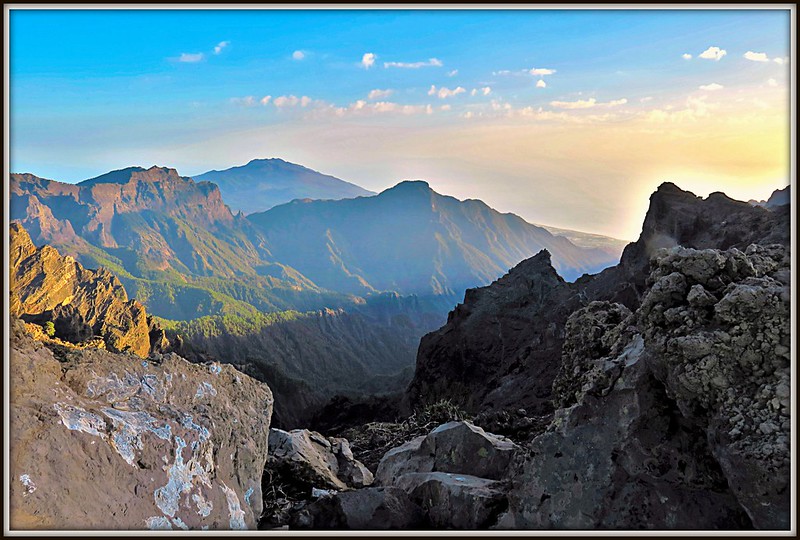
Why La Palma is Like This vol. I: The Seamount that Soared
This post first appeared on Patreon. To get early access, plus exclusive extras, please visit my Patreon page.
Now that we’ve got the geologic context of the Canary Islands as a whole figured out, it’s time to zero in on La Palma. How did she get here? Why are all the recent eruptions happening only on one half of her? What might be in store for the future? Does the fact that the most recent eruption is the longest and most voluminous of her entire recorded history mean the island is doomed? And is her active volcanic ridge, Cumbre Vieja, going to fall into the ocean and wipe out the East Coast of North America?
(I won’t keep you in suspense on that last one: the answer is almost certainly a resounding no. So while we’ll talk a bit about former collapses that have shaped the island, we won’t be spending any time on the megatsunami theory. Sorry not sorry.)
A Brief History of La Palma
La Palma is the second-youngest Canary island, and is still growing. She is, in fact, the most vigorously volcanic of the Canary Islands, boasting the most eruptions on record since the Spanish settlers arrived. And that’s just the last 500-ish years of her history: she’s actually about four million years old, if you count from her birth as a bouncing baby seamount. Nearly all of those years involve very hot rocks. (more…)
Ghostly Geology
Halloween is here! This is my favorite part of fall: costumes, spooky stuff, decorating in black not only allowed but encouraged…. This is the holiday I was born for.
And I have some geology made for the holiday! This year, the theme is ghosts, and we’re going to visit some very ghostly geology and paleontology indeed.
1. Ghost Shrimp Haunts Ichnologist

This is a different kind of ghost shrimp than the ones under discussion, but it is metal enough for Halloween, so we’re rolling with it. Credit:
Freddie Alequin (CC BY-SA 2.0)
Paleontology isn’t just about bones and preserved bodies: a branch of it, ichnology*, also looks at the things those bodies left behind, like fossilized trails, tracks, nests, burrows, borings, excavations, and even the divots left by pee. In this post, my favorite ichnologist, Tony Martin, talks about a very unusual trace he found that would be even more exciting to find in the fossil record.
Life Traces of the Georgia Coast: Ghost Shrimp Whisperer
Geologists love ghost shrimp, too, because of how their burrows are so numerous, fossilize easily, and are sensitive shoreline indicators. I wrote about this before with regard to how geologists in the 1960s were able to map ancient barrier islands of the Georgia coastal plain by looking for trace fossils of these burrows. Since then, geologists and paleontologists have identified and applied these sorts of trace fossils worldwide, and in rocks from the Permian Period to the Pleistocene Epoch.
I could prattle on about ghost shrimp and their ichnological incredibleness for the rest of the year, but will spare you of that, gentle reader, and instead will get to the point of this post. Just when I thought I’d learned nearly everything I needed to know about ghost-shrimp ichnology, one shrimp decided I needed to have my eyes opened to some traces I had never seen them make before just a few months ago.
*Not to be confused with ichthyology, which has to do with fishies. It’ll help to remember that ikhnos means “track” or “trace” in Greek, while ikhthus means “fish.”
2. Ghosts of Minerals Past (more…)