Mount St. Helens Montage I
Before other projects intervened, I did a long series of posts on the May 18, 1980 eruption of Mount St. Helens. I’d made it all the way to the blast deposits before my magma chamber collapsed. Part of the problem was not having good photos of said deposits ready to hand. Part of it was plain cowardice. And then a lot of other fascinating stuff happened. So the series, like a Cascades volcano, went dormant.
But dormant volcanoes roar to life again, and so shall The Cataclysm.
Right now, I’m spelunking the USGS ScienceBase Catalog, pulling every single Mount St. Helens photo I can find.
I’m combining those photos with the ones I pulled during an expedition to a previous incarnation of their catalog. And then, I’m going to reboot the series here with all of those lovely new finds. We can even do video versions! There are thousands upon thousands of astounding, informative, and often gorgeous photos available, and we shall make the best possible use of them.
Bad news is, it’s slow going. And everything’s jumbled. It’ll take a good while before I’ve got it all sorted.
Good news: you don’t have to wait before feasting your eyes, because I’m going to start sharing some of the best of the best right now.
Are your eyes hungry? Are they ready to feast upon some magnificent Mount St Helens? Excellent.
One of the best parts of going through the entire database is finding good candidates for before-and-after gifs. Seeing individual photos of what things were like before and after the eruption is striking enough, but seeing the same photos in gif form is stupefying.

Mount St. Helens from Coldwater II, before and after the May 18,1980 eruption. Credit: USGS / Dana Hunter
This gif combines a photograph taken on May 17th, 1980 with one taken on on September 10th, 1980 from roughly the same spot on what is now Johnston Ridge. It’s jarring to see the top of the mountain suddenly gone, the forest gone, glaciers and landmarks obliterated. And what really bakes my noodle is the fact that most of that devastation happened over the course of just a few minutes.
Wow.
Here’s another gif showing the Plains of Abraham before and after the eruption:

The Plains of Abraham, two years before and one year after the cataclysm. Credit: USGS / Dana Hunter
The first photo was taken in 1978. It’s your typical Cascades scene, with forests abounding all over the picturesque ridges. And then comes the view in 1981, where everything has been stripped bare and buried under thick ash and other volcanic debris. More than a year after the eruption, nothing grows. Some folks thought it never would. And looking at this, can you blame them?

“Oblique aerial view from Air National Guard search and rescue helicopter, showing Mount St. Helens erupting vigorously.” Photo taken at ~10:30 AM on May 18, 1980. Credit: USGS / Dana Hunter
There are many photos showing Mount St. Helens in eruption on that day. They’re clearer, more detailed, utterly breathtaking But something about this imperfect picture, showing the volcano in the distance hurling its Plinian column into an already ash-choked sky, grips me. I love how Mount St. Helens isn’t centered. I love how gloomy everything is – and remember, this had started out as a gloriously clear day, so that is isn’t the typical Pacific Northwest cloud ceiling shutting out the sun. And the clear-cut ridges in the foreground with their isolated patches of forest show it’s not just a volcano that can denude slopes.
I did a bit of Photoshop Express magic to enhance this one and remove some reflections, but it’s mostly as-is.
Now, this next photo isn’t going to look like much.

“Beginning of thrust fault in the crater floor – the ‘Outward Bounď thrust.” August 12, 1982. Credit: USGS / Don Swanson
But like the crack in Amy Pond’s wall, this little crack in the crater floor of Mount St. Helens was destined to become a very big deal indeed.
Just linger on it for a moment. Look at how itty bitty it is – that’s a Swiss Army knife for scale, so it’s not very large or tall. It virtually looks like a crack in mud in a farmer’s field. Note the date. All right? We’ll come back to that fault here in a moment.

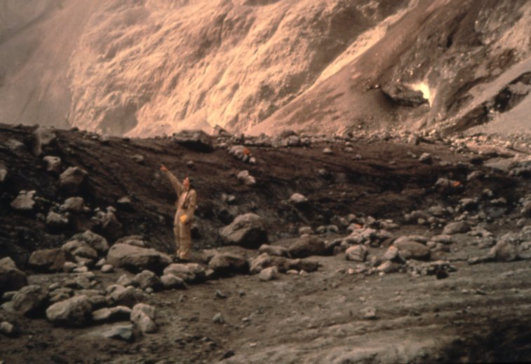
“Six days later, Christina Heliker at the Outward Bound thrust fault in the crater floor.” August 18, 1982. Credit: USGS / Don Swanson
I love this photo so, so much. It basically looks like an illustration for a science fiction story about colonizing Mars. I love USGS geologist Christina Heliker pointing of over the ridge, as if she’d spotted something flying in an alien sky. This photo doesn’t look like it’s anything to do with Earth at all. But it’s an Earthling doing earth science within the crater of an active (!) earthbound volcano. Which, honestly, is pretty darned extraordinary, considering Mount St. Helens was still in an eruptive phase at that point!
Oh, and that ridge? It’s the Outward Bound thrust fault. It’s just six days older.
Volcanoes are incredible entities!
Stay tuned for much more. I’ve got a whole ‘nother crop of Mount St. Helens growing, plus a return to Monte Nuovo coming, and later this month we’ll be touring Pompeii