42 for Loowit’s 42nd vol. 1: Pre-1980 Majesty
What’s the answer to life, the Universe, and how many years it’s been since Loowit (Mount St. Helens) erupted? Why, 42, of course! We’ve plundered the archives of the United States Geological Survey and the US Forest Service for 42 of the best historical photos, plus bonus featured images.
Grab your towels and join me on an epic journey back to the 20th Century, in those years when plate tectonics was still in its infancy, volcanology was still young, and Loowit had yet to stir.

Loowit in an undated pre-eruption photo, viewed across Spirit Lake. Credit: USFS
She rose serene above the placid mountain waters of Spirit Lake. She was one of those perfect conical ice cream scoops typical of Pacific Northwest volcanoes. We called her “America’s Fuji” and appended her to postcards galore. We loved her.
But even back when it seemed like her perfection would never be marred by anything so gauche as volcanic unrest, geologists knew: the quiet wouldn’t last.

Loowit and Spirit Lake framed by autumn leaves in an undated pre-eruption photo. Credit: USFS
She’s so beautiful, but like so many beautiful things, she’s dangerous. She’s the most dangerous volcano in the West.

Loowit and Spirit Lake framed by evergreens in an undated pre-eruption photo. Credit: USFS
In the decades before she erupted, geologists scoured her flanks and cut trenches in her deposits, trying to assess when Sleeping Beauty would awaken on the wrong side of the bed.

Shoestring Glacier on Mount St. Helens, viewed from the southeast. Photo from May, 1965. Image and caption credit: USGS
No one knew when she would erupt. No one predicted that some of her gorgeous glaciers would be destroyed, and others beheaded.

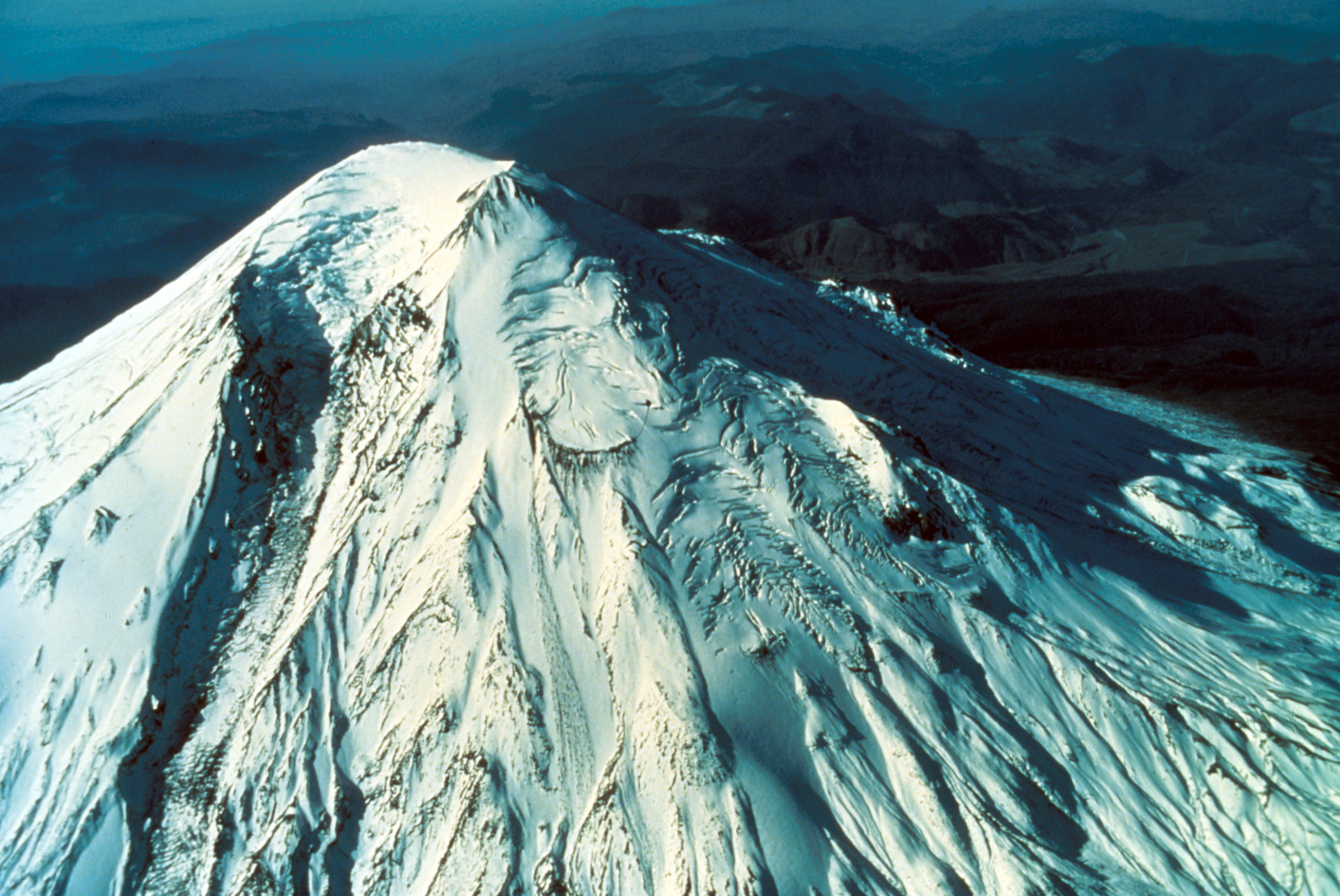
Aerial view of Mount St. Helens’ southeast flank, showing Shoestring Glacier, debris fan, “worm complex” lava flows. Skamania County, Washington. September 28, 1979. Caption and image credit: USGS
Her violent history became ever more clear, supplemented by Native American legend. Tribes in the area had lived with the capricious tempers of Loowit and her kinfolk for thousands of years. Between them and the geologists, we knew that ice would turn to fire, someday.

Aerial view of summit region of Mount St. Helens looking almost due east. Mount Adams visible in the background. Skamania and Yakima Counties, Washington. September 28, 1979. Caption and image credit: USGS
Most of us figured that day would be far in her future. But a trio of young geologists had read her rocks, and knew better. “[T]he volcano,” they said, “last active in 1857, will erupt again—perhaps within the next few decades.”
They had no idea that they’d have just half a decade to wait for their prediction to come true.
Featured image: “Oblique aerial view of Mount St. Helens prior to the eruption. It is nearly a symmetrical cone-shaped volcano in the Cascade Range. Elevation 9,471 feet. View looking westerly across the north face of the volcano as we see the Goat Rocks feature on the north flank and the Dogs Head feature on the northwest flank. In center foreground is Shoestring Glacier and in the upper right hand corner is the North Fork Toutle River valley.” Image and caption courtesy USGS.

Rosetta Stones and Dana Hunter’s Unconformity wouldn’t be possible without you! If you like my content, there are many ways to show your support.


![]()
This website is a member of the Amazon Affiliates program. I get a small commission when you use my affiliate link to make a purchase.

Thank you so much for your support!