Why La Palma is Like This vol. I: The Seamount that Soared
This post first appeared on Patreon. To get early access, plus exclusive extras, please visit my Patreon page.
Now that we’ve got the geologic context of the Canary Islands as a whole figured out, it’s time to zero in on La Palma. How did she get here? Why are all the recent eruptions happening only on one half of her? What might be in store for the future? Does the fact that the most recent eruption is the longest and most voluminous of her entire recorded history mean the island is doomed? And is her active volcanic ridge, Cumbre Vieja, going to fall into the ocean and wipe out the East Coast of North America?
(I won’t keep you in suspense on that last one: the answer is almost certainly a resounding no. So while we’ll talk a bit about former collapses that have shaped the island, we won’t be spending any time on the megatsunami theory. Sorry not sorry.)
A Brief History of La Palma
La Palma is the second-youngest Canary island, and is still growing. She is, in fact, the most vigorously volcanic of the Canary Islands, boasting the most eruptions on record since the Spanish settlers arrived. And that’s just the last 500-ish years of her history: she’s actually about four million years old, if you count from her birth as a bouncing baby seamount. Nearly all of those years involve very hot rocks.
This pre-current eruption satellite Photo shows off her features well.
_La_Palma_%26_La_Gomera_Islands,_Canary_Islands_(cropped).jpg?ssl=1)
Landsat view of La Palma, filtered for clarity. Credit: USGS / O.V.E.R.V.I.E.W.
_La_Palma_%26_La_Gomera_Islands,_Canary_Islands_(cropped).jpg)
There’s reasons why she’s shaped like a shark’s tooth, and sports deep gouges in her northern bit, and lines of cones in her tail; why deep gouges chew through to her middle, and why cliffs and platforms abound on her flanks. Those reasons are pretty much all volcanoes, gravity, and erosion.
On our journey through her geologic past, we’re going to see an enormous variety of volcanism. We start on the ocean floor, watch seamounts grow into mighty shields, encounter explosive volcanoes all the way from rooster tails to cinder cones, stratovolcanoes to fissure eruptions, and a few varieties in between. There is an incredible amount of lava, and a disconcerting number of huge bits falling down.
This is what an oceanic hotspot is still busy building. It’s a lot. We’ll need a helpful map to keep everything sorted:

La Palma’s most important geologic features. Credit: Dana Hunter / Federico Di Paolo et al
La Palma is an island in basically two parts: the older, somewhat rounder collection of overlapping large volcanoes and seamounts that comprises her northern shield, and the narrower, young, and quite volcanically active Cumbre Vieja tail. We’re going to begin our exploration of La Palma’s geology by diving deep into her exposed heart in the northern shield, where her underwater life is wonderfully exposed on dry land.
Sea Rocks on Dry Land
Within the Caldera de Taburiente in the center of the northern shield, wonderfully outcropping in a ravine called the Barranco de Las Angustias, are rocks that actually belong on the bottom of the sea. They’re called the Seamount Series. They’re not just a marvelous, rare exposure of submarine volcanic rocks on dry land, but are the foundation upon which the island was built, and are its oldest bones.
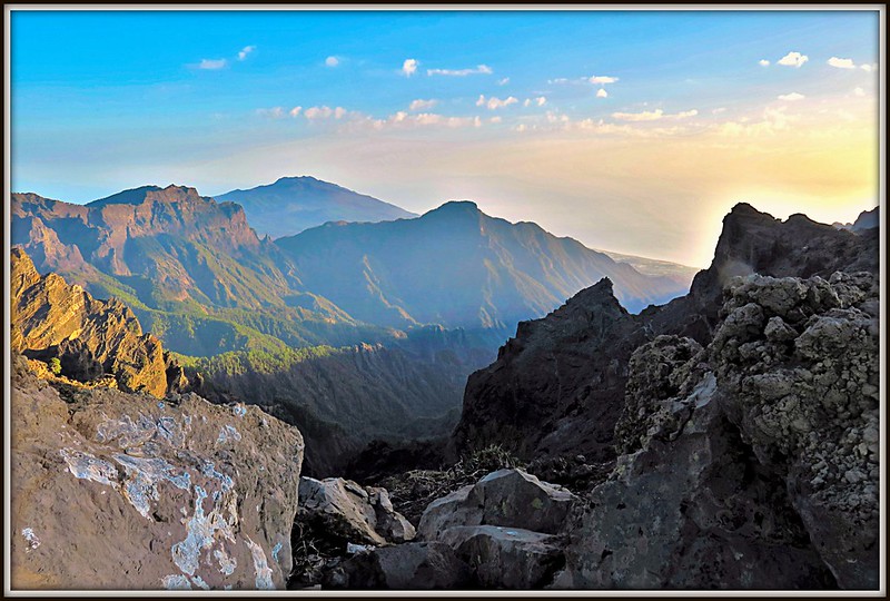
Do you want to know what the inside of a seamount looks like? Because here, you get a glorious, 3.6 kilometer cross-section through one. That’s pretty rare! Only La Gomera can also boast such a site on the Canary Islands.

Caldera de Taburiente. Credit: Michael Apel (CC BY-SA 3.0)
These “basal complexes” share the same general features:
Their oldest rocks are ocean floor sediments, which accumulated before the islands were born. As the islands grew, the sediments that weren’t buried were deformed and uplifted.
Thick piles of pillow lavas erupted on the seafloor and the growing seamount, indicating lava extruded under deep water.
Above the pillows, we find a volcanic breccia called hyaloclastite, which formed as the seamount neared the surface. We can see the eruptions become more explosive as the seamounts prepared to emerge and become islands.
We also see basaltic dyke swarms, in some places so thick that they form upwards of 80% of the outcrop in some places. Some of these fed eruptions; others never found their way out.
Plutons, bodies of magma that intruded and solidified within the volcanic pile. They cut through older dykes and are in turn cut by younger ones.
Related to that, we find deformed dykes, and even some deformed plutons, where new intruding magma bodies opened faults, tilted existing rocks, and thrust them out of their way.
With all this hot magma jostling around, metamorphism is inevitable. We get both hydrothermal metamorphism caused by hot, circulating fluids throughout, and contact metamorphism where the fresh plutonic magma bodies touched existing rocks.
Then we get fresh dykes, plugs, sills, and plutons where post-seamount magmas moved in and fed all that lovely sub-aerial, island-building volcanism which we’ll see in the next post.
Finally, we get unconformities! Post-uplift erosion cut away parts of the seamounts, leaving a temporal gap between the seamount segments and the later volcanics.
The Seamount Series has so much to tell us about how La Palma came to be, and when. Let’s have a listen.

A boulder of pillow lava with a dyke cutting it, Salto de la Estrechura in the Barranco de las Angustias. Wow! Credit: Falk2 (CC BY-SA 4.0)
La Palma’s Origin Story
About four million years ago, the Canary Hotspot sent magma probing through the crust west of the islands of La Gomera and Tenerife. If humans had been around then, and had seismometers, they would have noticed distinct swarms of earthquakes as rising dykes of molten rock cracked the cool crustal rocks, forcing a way through. The earthquakes would have built to a crescendo, then began a continuous vibration: the distinctive signal known as harmonic tremor , signaling that an eruption had begun.
We don’t know if that first eruption was large or small, short or long. We do know that, thousands of meters below the surface of the sea, nothing particularly explosive happened. Instead, basalt lava formed piles of pillows; a bouncing baby seamount. La Palma was conceived.
And that’s how it would remain for almost two million years. Countless eruptions formed countless more piles of pillows, building the seamount higher and higher. Eventually, the underwater volcano reached shallower depths, just a few hundred meters below the surface. With the pressure off, things turned explosive. Pillow lavas still formed, but escaping gasses shattered them, leaving their broken bits to consolidate into pillow breccias. Even more energetic eruptions broke the lavas into flat, glassy fragments that formed massive deposits of the volcanic breccia hyaloclastite.
As the seamount reached the surface, huge rooster tails of ash, water, and steam shot from the water. Waves battled the newborn volcanic island, trying to erode it back under the sea as soon as it emerged. It may have eroded into a seamount many times before a large eruption finally turned it from a submarine to a subaerial volcano. But in the end, it was a seamount no more: La Palma had arrived.
The Storybook Stones
The story of the Seamount Series wasn’t quite done. Injections of magma during its submarine phase had created dykes and plutons, but there were many more to come as subaerial volcanoes grew above it. Hydrothermal fluids circulated through the pile far millions of years, heated by successive intrusions, altering existing minerals, concentrating rare earthelements, and erasing the original magnetic orientation of magnetic minerals,
In places, so many dykes cut the original rocks that they nearly replaced them; those older rocks exist only as isolated bits. Plutons, formed from the magma bodies that fed both the seamount and subsequent volcanoes, can be hundreds of meters thick in places. The oldest gabbros (the underground version of basalt) in the northern part of the Caldera de Taburiente fed the seamount. If you place your hand on them, you’re touching the source of La Palma.

Dykes of the Seamount Series in the Caldera de Taburiente. Credit: Axel Brocke (CC BY 2.0)
At some point after the formation of the seamount, its rocks were uplifted to around 1,000 meters above sea level, and tilted about 50° to the southwest. That tilt allows us to see which dykes fed the seamount; the dykes feeding the subsequent subaerial eruptions aren’t rotated.
All of these rocks tell the early history of La Palma, of the little seamount that grew and grew and was thrust into the sky. They’re waiting to speak to you in the deep ravines of the caldera. They’ll tell their story to countless generations to come.
La Palma’s future now belonged to the mighty volcanoes of the northern shield. We’ll hear their story next.
References:
Barker et al (2015): The magma plumbing system for the 1971 Teneguía eruption on La Palma, Canary Islands. Contribbutions to Mineralogy and Petrology vol 170 #54
Carracedo et al (2001): Geology and Volcanology of La Palma and El Hierro, Western Canaries. Estudios Geologicos vol. 57 (5-6)
Groom, Simon: An integrated study of the magmatic products linked to the Cumbre Nueva Collapse, La Palma. Dept. Earth and Planetary Sciences, Birbeck, University of London (Unpublished PhD Thesis)
Featured image: Caldera de Taburiente. Credit: Rolf Dietrich Brecher (CC BY 2.0)

Rosetta Stones and Dana Hunter’s Unconformity wouldn’t be possible without you! If you like my content, there are many ways to show your support.

![]()

This website is a member of the Amazon Affiliates program. I get a small commission when you use my affiliate link to make a purchase.